
With a combined population of less than 10,000, Baarle-Hertog and Baarle-Nassau are off the beaten tourist path. I will admit that not many people would crave to go there. Between getting high in Amsterdam and the beers of Belgium, it is not uncommon for tourists to completely skip this little gem of international co-operation.
It is a situation that arose out of medieval land deals, centuries before either Belgium or the Netherlands existed in their current form. Today it is one of only a few places in the world with a border this complicated. We aren’t talking about town lines or city lines or state lines. This is an international boundary, mutually respected and internationally enforced. And it looks something like this.
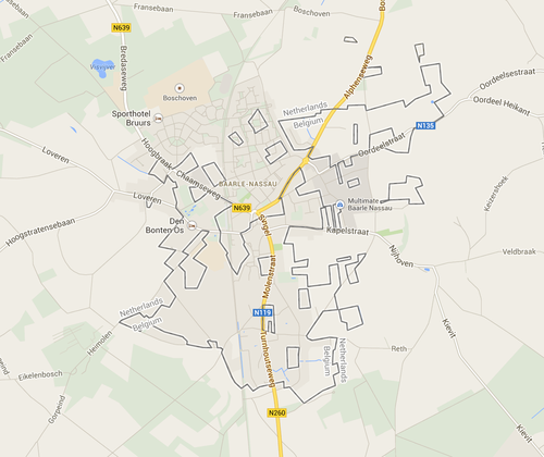
Indeed, it blew my mind too. The twin towns of Baarle-Hertog and Baarle-Nassau (one town, to be non-technical) straddle the international border between Belgium and the Netherlands. What makes it even more interesting is that there are tiny enclaves of both the Dutch and Belgian sides, some of which have another enclave embedded inside them.
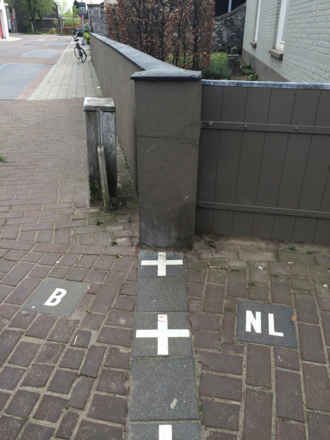
People assumed where they lived, and affiliated with the country they felt more at home with. This included choosing who they legally paid taxes to. Until 1995 came along, and the two governments finally fixed the last of the border. It cuts buildings in half, cafés into two and streets into small pieces.
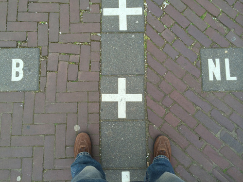
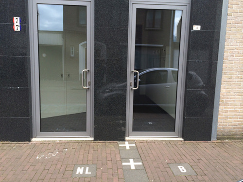
So, where does one legally live if their house is cut in half? Well, it’s simple: wherever their front door is! Did the Dutch annoy you last week? Just move your front door and move to Belgium. What makes it even more interesting is when you have to decide which house you want to have your birthday bash at. The Dutch one or the Belgian one? Maybe the guests can decide for themselves.
Why is Baarle-Hertog like that?
The short answer is that a duke kept the good fields.
In 1198, Henry I, Duke of Brabant, handed the land around Baarle to Godfried of Schoten, Lord of Breda. But he kept the parcels that were already farmed and already paying him rent. Those plots stayed with the duke, the “hertog”. Everything else went to Breda, which passed to the House of Nassau by marriage in 1403. So from the start the village was a patchwork of fields belonging to two different lords, with no thought given to drawing a tidy line.
For four centuries that did not matter much. Then the Dutch Revolt split the Low Countries. Under the Peace of Westphalia in 1648, the Barony of Breda, and with it Baarle-Nassau, became part of the Dutch Republic. The duke’s parcels stayed with the Spanish Netherlands, which later became Belgium. A medieval property map had turned into an international border.
Belgium and the Netherlands tried to tidy it up in the Treaty of Maastricht in 1843. At Baarle they gave up, and instead recorded the ownership of every one of the 5,732 parcels of land individually. Even that left a few unresolved. The last of them was not settled until 1995, which is why the border was only properly marked in living memory.
The result today is 22 Belgian enclaves inside the Netherlands, and 8 Dutch enclaves, 7 of which sit inside the Belgian ones. The smallest Belgian enclave is a field of about 2,600 square metres. The whole arrangement makes Baarle the most complicated international border in the world, by number of enclaves.
How the town copes
The front door rule is real. A house belongs to the country its front door opens into, and where a door sits right on the line, the house gets two numbers and two flags. Shops have moved their front doors over the years to pick the tax regime or the opening hours they preferred.
The border has had stranger consequences. During the First World War, the Netherlands was neutral and Belgium was occupied, but the German army could not reach the Baarle-Hertog enclaves without crossing Dutch soil. The Belgians used that to run a radio station from unoccupied Belgian ground in the middle of a neutral country. In 2020, the two countries set different lockdown rules, so a shop with the border running through it was open on one side of the line and closed on the other.
Mostly, though, it works. The two municipalities share services, the residents share a village, and the crosses on the pavement are a tourist attraction rather than a problem.
Visiting Baarle
Baarle sits about 25 kilometres south of Breda and 15 kilometres north of Turnhout, which makes it an easy half-day from either, or from Antwerp. There is no railway. Buses run from Breda, Tilburg and Turnhout, and there is plenty of parking if you drive.
Look down. The border is marked with white crosses in the pavement and B and NL tiles either side, and it runs through the main shopping street, so you cross it a dozen times without trying. The house numbers carry small flags. The tourist office in the centre sells a map of all the enclaves, which is the only way to find the smaller ones.
It is truly extraordinary how such an arrangement exists in harmony. Maybe other countries with border disputes should learn something from the little towns of Baarle-Hertog and Baarle-Nassau.